


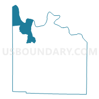
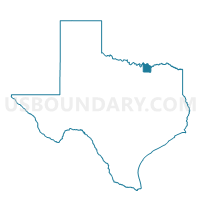
Voting District 0019, Grayson County, Texas
About
Outline

Summary
| Unique Area Identifier | 673463 |
| Name | Voting District 0019 |
| County | Grayson County |
| State | Texas |
| Area (square miles) | 64.32 |
| Land Area (square miles) | 50.34 |
| Water Area (square miles) | 13.97 |
| % of Land Area | 78.27 |
| % of Water Area | 21.73 |
| Latitude of the Internal Point | 33.83810120 |
| Longtitude of the Internal Point | -96.85711170 |
Maps

Graphs
Select a template below for downloading or customizing gragh for Voting District 0019, Grayson County, Texas


Neighbors
Neighoring Voting District (by Name) Neighboring Voting District on the Map
- Voting District 0009, Cooke County, TX
- Voting District 0016, Grayson County, TX
- Voting District 0017, Grayson County, TX
- Voting District 0022, Grayson County, TX
- Voting District 0024, Grayson County, TX
- Voting District 106, Marshall County, OK
- Voting District 304, Marshall County, OK
- Voting District 312, Love County, OK
Top 10 Neighboring County Subdivision (by Population) Neighboring County Subdivision on the Map
- Northwest Grayson CCD, Grayson County, TX (23,440)
- North Marshall CCD, Marshall County, OK (8,588)
- East Love CCD, Love County, OK (7,505)
- South Marshall CCD, Marshall County, OK (7,252)
- Callisburg CCD, Cooke County, TX (5,994)
Top 10 Neighboring Place (by Population) Neighboring Place on the Map
Top 10 Neighboring Unified School District (by Population) Neighboring Unified School District on the Map
- Whitesboro Independent School District, TX (9,640)
- Madill Public Schools, OK (8,627)
- Pottsboro Independent School District, TX (8,293)
- Kingston Public Schools, OK (7,213)
- S and S Consolidated Independent School District, TX (4,718)
- Marietta Public School, OK (4,360)
Top 10 Neighboring State Legislative District Lower Chamber (by Population) Neighboring State Legislative District Lower Chamber on the Map
- State House District 62, TX (154,792)
- State House District 68, TX (135,942)
- State House District 49, OK (38,581)
Top 10 Neighboring State Legislative District Upper Chamber (by Population) Neighboring State Legislative District Upper Chamber on the Map
- State Senate District 30, TX (823,594)
- State Senate District 6, OK (79,973)
- State Senate District 14, OK (76,649)
Top 10 Neighboring 111th Congressional District (by Population) Neighboring 111th Congressional District on the Map
- Congressional District 26, TX (915,137)
- Congressional District 4, TX (846,142)
- Congressional District 4, OK (785,424)
Top 10 Neighboring Census Tract (by Population) Neighboring Census Tract on the Map
- Census Tract 1, Cooke County, TX (5,892)
- Census Tract 942, Love County, OK (4,640)
- Census Tract 3.03, Grayson County, TX (4,478)
- Census Tract 3.02, Grayson County, TX (4,469)
- Census Tract 946.98, Marshall County, OK (3,734)
- Census Tract 948.01, Marshall County, OK (3,512)
- Census Tract 3.04, Grayson County, TX (3,369)
Top 10 Neighboring 5-Digit ZIP Code Tabulation Area (by Population) Neighboring 5-Digit ZIP Code Tabulation Area on the Map
- 75092, TX (22,839)
- 76273, TX (9,135)
- 73439, OK (7,400)
- 75076, TX (7,378)
- 73448, OK (5,784)
- 76245, TX (1,780)
- 76264, TX (1,412)
- 73440, OK (398)